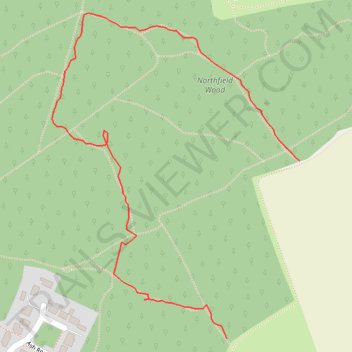
Northfield Wood
- Distance: 0.7 mi
- Elevation gain: 26 ft
- Maximum elevation: 203 ft
- Elevation loss: 16 ft
- Minimum elevation: 184 ft
- Moving time: 16 m 32 s
- Moving speed: 2.5 mph
- Maximum speed: 12.2 mph
- Total time: 21 m 28 s
- Global speed: 1.9 mph
Interactive trail map
Trail profile
- Distance: 0.7 mi
- Elevation gain: 26 ft
- Maximum elevation: 203 ft
- Elevation loss: 16 ft
- Minimum elevation: 184 ft
- Moving time: 16 m 32 s
- Moving speed: 2.5 mph
- Maximum speed: 12.2 mph
- Total time: 21 m 28 s
- Global speed: 1.9 mph
About this trail
Name: Northfield Wood trail, distance, elevation, map, profile, GPS track
Start: Northfield Road, Mid Suffolk, Suffolk, England, IP14 3HD, United Kingdom (52.19872 0.96177)
End: Northfield Road, Mid Suffolk, Suffolk, England, IP14 3HE, United Kingdom (52.20092 0.96324)
Coordinates: 52.19872 0.95825 52.20274 0.96324