Sherwood Reserve
- Distance: 1.5 mi
- Elevation gain: 75 ft
- Maximum elevation: 554 ft
- Elevation loss: 75 ft
- Minimum elevation: 486 ft
- Moving time: 39 m 30 s
- Moving speed: 2.2 mph
- Maximum speed: 3.6 mph
- Total time: 42 m 27 s
- Global speed: 2.1 mph
Interactive trail map
Trail profile
- Distance: 1.5 mi
- Elevation gain: 75 ft
- Maximum elevation: 554 ft
- Elevation loss: 75 ft
- Minimum elevation: 486 ft
- Moving time: 39 m 30 s
- Moving speed: 2.2 mph
- Maximum speed: 3.6 mph
- Total time: 42 m 27 s
- Global speed: 2.1 mph
About this trail
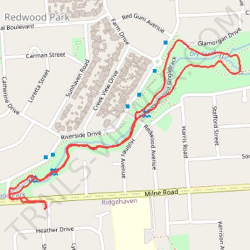
Name: Sherwood Reserve trail, distance, elevation, map, profile, GPS track
Coordinates: -34.81681 138.70604 -34.81219 138.71373
Other hiking, mountain biking, running and outdoor activity trails
Click on a trail to view its statistics, map and profile.
Dry Creek to the Triangle
Australia > South Australia > Adelaide
Distance: 13.2 mi • Elevation gain: 571 ft • Maximum elevation: 669 ft
Dry Creek Trail
Australia > South Australia > Adelaide
Distance: 14.0 mi • Elevation gain: 863 ft • Maximum elevation: 669 ft