Thank you for supporting this site ❤️
Make a donation
Make a donation
Gear up for your next adventure:
As an Amazon Associate, this site earns from qualifying purchases at no extra cost to you.
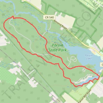
Parvin State Park Forest Road and Long Trail Loop
- Distance: 4.6 mi
- Elevation gain: 112 ft
- Maximum elevation: 102 ft
- Elevation loss: 115 ft
- Minimum elevation: 62 ft
- Moving time: 53 m 38 s
- Moving speed: 5.1 mph
- Maximum speed: 6.6 mph
- Total time: 53 m 38 s
- Global speed: 5.1 mph
Interactive trail map
Thank you for supporting this site ❤️
Make a donation
Make a donation
Gear up for your next adventure:
As an Amazon Associate, this site earns from qualifying purchases at no extra cost to you.
Trail profile
- Distance: 4.6 mi
- Elevation gain: 112 ft
- Maximum elevation: 102 ft
- Elevation loss: 115 ft
- Minimum elevation: 62 ft
- Moving time: 53 m 38 s
- Moving speed: 5.1 mph
- Maximum speed: 6.6 mph
- Total time: 53 m 38 s
- Global speed: 5.1 mph
Thank you for supporting this site ❤️
Make a donation
Make a donation
Gear up for your next adventure:
As an Amazon Associate, this site earns from qualifying purchases at no extra cost to you.
About this trail
Name: Parvin State Park Forest Road and Long Trail Loop trail, distance, elevation, map, profile, GPS track
Coordinates: 39.50166 -75.16156 39.51904 -75.13114
Topography: Pittsgrove Township topographic map, elevation, terrain
Thank you for supporting this site ❤️
Make a donation
Make a donation
Gear up for your next adventure:
As an Amazon Associate, this site earns from qualifying purchases at no extra cost to you.