Make a donation
Gear up for your next adventure:
As an Amazon Associate, this site earns from qualifying purchases at no extra cost to you.
It'll Bluff Out
#MTB
- Distance: 4.7 mi
- Elevation gain: 531 ft
- Maximum elevation: 1,214 ft
- Elevation loss: 577 ft
- Minimum elevation: 1,027 ft
Interactive trail map
Make a donation
Gear up for your next adventure:
As an Amazon Associate, this site earns from qualifying purchases at no extra cost to you.
Trail profile
- Distance: 4.7 mi
- Elevation gain: 531 ft
- Maximum elevation: 1,214 ft
- Elevation loss: 577 ft
- Minimum elevation: 1,027 ft
Make a donation
Gear up for your next adventure:
As an Amazon Associate, this site earns from qualifying purchases at no extra cost to you.
About this trail
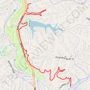
Name: It'll Bluff Out trail, distance, elevation, map, profile, GPS track
Start: It'll Bluff Out, Bella Vista, Benton County, Arkansas, 72715, United States (36.44409 -94.22606)
End: Back 40, Dug Hill, Bella Vista, Benton County, Arkansas, 72715, United States (36.46795 -94.24005)
Coordinates: 36.44409 -94.24445 36.46795 -94.22584
Topography: Benton County topographic map, elevation, terrain
Make a donation
Gear up for your next adventure:
As an Amazon Associate, this site earns from qualifying purchases at no extra cost to you.