Make a donation
Gear up for your next adventure:
As an Amazon Associate, this site earns from qualifying purchases at no extra cost to you.
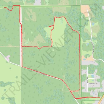
Deep Creek Preserve
- Distance: 7.4 mi
- Elevation gain: 30 ft
- Maximum elevation: 49 ft
- Elevation loss: 30 ft
- Minimum elevation: 36 ft
- Moving time: 2 h 36 m
- Moving speed: 2.8 mph
- Maximum speed: 3.8 mph
- Total time: 2 h 38 m
- Global speed: 2.8 mph
Interactive trail map
Make a donation
Gear up for your next adventure:
As an Amazon Associate, this site earns from qualifying purchases at no extra cost to you.
Trail profile
- Distance: 7.4 mi
- Elevation gain: 30 ft
- Maximum elevation: 49 ft
- Elevation loss: 30 ft
- Minimum elevation: 36 ft
- Moving time: 2 h 36 m
- Moving speed: 2.8 mph
- Maximum speed: 3.8 mph
- Total time: 2 h 38 m
- Global speed: 2.8 mph
Make a donation
Gear up for your next adventure:
As an Amazon Associate, this site earns from qualifying purchases at no extra cost to you.
About this trail
Name: Deep Creek Preserve trail, distance, elevation, map, profile, GPS track
Start: Orange Trail, Alamana, Volusia County, Florida, United States (28.95140 -81.09736)
End: Orange Trail, Alamana, Volusia County, Florida, United States (28.95142 -81.09735)
Coordinates: 28.95120 -81.12376 28.97359 -81.09730
Topography: Volusia County topographic map, elevation, terrain
Make a donation
Gear up for your next adventure:
As an Amazon Associate, this site earns from qualifying purchases at no extra cost to you.
Other hiking, mountain biking, running and outdoor activity trails
Click on a trail to view its statistics, map and profile.
Deep Creek Preserve - White Trail
United States > Florida > Volusia County > Alamana
Distance: 12.9 mi • Elevation gain: 118 ft • Maximum elevation: 56 ft
Deep Creek Extended Loop
United States > Florida > Volusia County
Distance: 5.5 mi • Elevation gain: 26 ft • Maximum elevation: 49 ft