Thank you for supporting this site ❤️
Make a donation
Make a donation
Gear up for your next adventure:
As an Amazon Associate, this site earns from qualifying purchases at no extra cost to you.
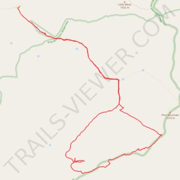
Pine Mountain Wilderness Loop Hike
- Distance: 12.3 mi
- Elevation gain: 2,287 ft
- Maximum elevation: 6,772 ft
- Elevation loss: 2,333 ft
- Minimum elevation: 5,102 ft
- Moving time: 5 h 10 m
- Moving speed: 2.4 mph
- Maximum speed: 3.7 mph
- Total time: 6 h 12 m
- Global speed: 2.0 mph
Interactive trail map
Thank you for supporting this site ❤️
Make a donation
Make a donation
Gear up for your next adventure:
As an Amazon Associate, this site earns from qualifying purchases at no extra cost to you.
Trail profile
- Distance: 12.3 mi
- Elevation gain: 2,287 ft
- Maximum elevation: 6,772 ft
- Elevation loss: 2,333 ft
- Minimum elevation: 5,102 ft
- Moving time: 5 h 10 m
- Moving speed: 2.4 mph
- Maximum speed: 3.7 mph
- Total time: 6 h 12 m
- Global speed: 2.0 mph
Thank you for supporting this site ❤️
Make a donation
Make a donation
Gear up for your next adventure:
As an Amazon Associate, this site earns from qualifying purchases at no extra cost to you.
About this trail
Name: Pine Mountain Wilderness Loop Hike trail, distance, elevation, map, profile, GPS track
Start: Nelson Trail, Yavapai County, Arizona, United States (34.32325 -111.83413)
End: Nelson Trail, Yavapai County, Arizona, United States (34.32640 -111.83611)
Coordinates: 34.28038 -111.83663 34.32640 -111.78839
Topography: Yavapai County topographic map, elevation, terrain
Thank you for supporting this site ❤️
Make a donation
Make a donation
Gear up for your next adventure:
As an Amazon Associate, this site earns from qualifying purchases at no extra cost to you.