Thank you for supporting this site ❤️
Make a donation
Make a donation
Gear up for your next adventure:
As an Amazon Associate, this site earns from qualifying purchases at no extra cost to you.
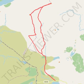
Walk up Carn Dearg and Sgor Gaibhre from near Loch Eigheach
- Distance: 16.7 mi
- Elevation gain: 3,153 ft
- Maximum elevation: 3,130 ft
- Elevation loss: 3,153 ft
- Minimum elevation: 866 ft
- Moving time: 6 h 25 m
- Moving speed: 2.6 mph
- Maximum speed: 4.1 mph
- Total time: 7 h 24 m
- Global speed: 2.3 mph
Interactive trail map
Thank you for supporting this site ❤️
Make a donation
Make a donation
Gear up for your next adventure:
As an Amazon Associate, this site earns from qualifying purchases at no extra cost to you.
Trail profile
- Distance: 16.7 mi
- Elevation gain: 3,153 ft
- Maximum elevation: 3,130 ft
- Elevation loss: 3,153 ft
- Minimum elevation: 866 ft
- Moving time: 6 h 25 m
- Moving speed: 2.6 mph
- Maximum speed: 4.1 mph
- Total time: 7 h 24 m
- Global speed: 2.3 mph
Thank you for supporting this site ❤️
Make a donation
Make a donation
Gear up for your next adventure:
As an Amazon Associate, this site earns from qualifying purchases at no extra cost to you.
About this trail
Name: Walk up Carn Dearg and Sgor Gaibhre from near Loch Eigheach trail, distance, elevation, map, profile, GPS track
Start: B846, Perth and Kinross, Scotland, United Kingdom (56.68636 -4.53815)
End: B846, Perth and Kinross, Scotland, United Kingdom (56.68638 -4.53813)
Coordinates: 56.68631 -4.59241 56.77265 -4.53802
Thank you for supporting this site ❤️
Make a donation
Make a donation
Gear up for your next adventure:
As an Amazon Associate, this site earns from qualifying purchases at no extra cost to you.