Les sentiers de la Wormsa
- Distance: 6.9 mi
- Elevation gain: 1,946 ft
- Maximum elevation: 3,156 ft
- Elevation loss: 1,952 ft
- Minimum elevation: 1,614 ft
Interactive trail map
Trail profile
- Distance: 6.9 mi
- Elevation gain: 1,946 ft
- Maximum elevation: 3,156 ft
- Elevation loss: 1,952 ft
- Minimum elevation: 1,614 ft
About this trail
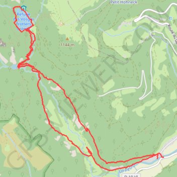
Name: Les sentiers de la Wormsa trail, distance, elevation, map, profile, GPS track
Coordinates: 48.00877 7.02273 48.03183 7.05441
Other hiking, mountain biking, running and outdoor activity trails
Click on a trail to view its statistics, map and profile.
Track vom: 2020-06-13 07:00
Germany > North Rhine-Westphalia > Kreis Wesel > Schermbeck
Distance: 422.5 mi • Elevation gain: 17,392 ft • Maximum elevation: 3,022 ft
Track vom: 2020-06-27 07:26
Germany > Bavaria > Landkreis Ostallgäu > Halblech
Distance: 427.6 mi • Elevation gain: 14,131 ft • Maximum elevation: 2,989 ft
Riethoven naar Oostenrijk
Netherlands > North Brabant > Riethoven > Eind
Distance: 573.0 mi • Elevation gain: 44,715 ft • Maximum elevation: 6,224 ft