Mission Peak Loop
Interactive trail map
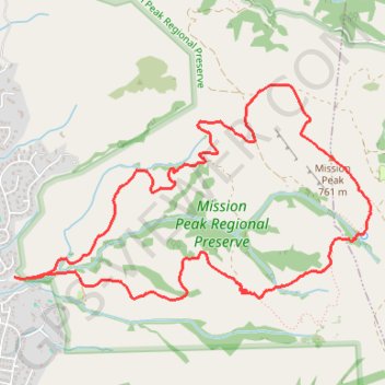
Trail profile
- Distance: 5.8 mi
- Elevation gain: 2,129 ft
- Maximum elevation: 2,500 ft
- Elevation loss: 2,129 ft
- Minimum elevation: 387 ft
About this trail
Name: Mission Peak Loop trail, distance, elevation, map, profile, GPS track
Coordinates: 37.50281 -121.90833 37.51753 -121.87760
Topography: Fremont topographic map, elevation, terrain
Other hiking, mountain biking, running and outdoor activity trails
Click on a trail to view its statistics, map and profile.
Mission Peak via Peak Trail in Mission Peak Regional Preserve
United States > California > Alameda County > Fremont
The Mission Peak via Peak Trail offers a demanding but rewarding hike that presents remarkable panoramic views throughout the ascent. As hikers climb, they are treated to vistas of the Bay Area, including San Francisco, the East Bay hills, and distant landmarks like Mount Diablo. At the summit, the iconic…
Distance: 3.3 mi • Elevation gain: 2,028 ft • Maximum elevation: 2,464 ft
Mission Peak via Hidden Valley Trail in Mission Peak Regional Preserve
United States > California > Alameda County > Fremont
Hiking the Hidden Valley Trail to Mission Peak offers expansive vistas of the San Francisco Bay Area, including landmarks like Mount Tamalpais and Mount Diablo in the distance. Along the trail, hikers traverse open grasslands and may encounter local wildlife such as grazing cattle and soaring birds of prey. At…
Distance: 6.2 mi • Elevation gain: 2,136 ft • Maximum elevation: 2,493 ft