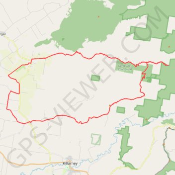
Tannymorel - Bald Mountain
Interactive trail map
Trail profile
- Distance: 36.7 mi
- Elevation gain: 4,790 ft
- Maximum elevation: 3,917 ft
- Elevation loss: 4,790 ft
- Minimum elevation: 1,611 ft
About this trail
Name: Tannymorel - Bald Mountain trail, distance, elevation, map, profile, GPS track
Coordinates: -28.29309 152.21799 -28.21466 152.41654
Other hiking, mountain biking, running and outdoor activity trails
Click on a trail to view its statistics, map and profile.
Warwick - Gatton
Australia > Queensland > Warwick
#Bike
Distance: 77.8 mi • Elevation gain: 2,664 ft • Maximum elevation: 1,909 ft