Thank you for supporting this site ❤️
Make a donation
Make a donation
Gear up for your next adventure:
As an Amazon Associate, this site earns from qualifying purchases at no extra cost to you.
Red Peak
Interactive trail map
Thank you for supporting this site ❤️
Make a donation
Make a donation
Gear up for your next adventure:
As an Amazon Associate, this site earns from qualifying purchases at no extra cost to you.
Trail profile
- Distance: 15.5 mi
- Elevation gain: 3,209 ft
- Maximum elevation: 9,219 ft
- Elevation loss: 3,176 ft
- Minimum elevation: 6,194 ft
Thank you for supporting this site ❤️
Make a donation
Make a donation
Gear up for your next adventure:
As an Amazon Associate, this site earns from qualifying purchases at no extra cost to you.
About this trail
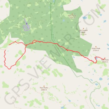
Name: Red Peak trail, distance, elevation, map, profile, GPS track
Start: Forest Service Road 36, El Dorado County, California, United States (38.93135 -120.32125)
End: Forest Service Road 36, El Dorado County, California, United States (38.93546 -120.31803)
Coordinates: 38.91665 -120.32284 38.93937 -120.22133
Topography: El Dorado County topographic map, elevation, terrain
Thank you for supporting this site ❤️
Make a donation
Make a donation
Gear up for your next adventure:
As an Amazon Associate, this site earns from qualifying purchases at no extra cost to you.