Thank you for supporting this site ❤️
Make a donation
Make a donation
Gear up for your next adventure:
As an Amazon Associate, this site earns from qualifying purchases at no extra cost to you.
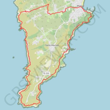
Cap de La Chèvre - Morgat
- Distance: 14.9 mi
- Elevation gain: 2,966 ft
- Maximum elevation: 315 ft
- Elevation loss: 2,963 ft
- Minimum elevation: 3 ft
Interactive trail map
Thank you for supporting this site ❤️
Make a donation
Make a donation
Gear up for your next adventure:
As an Amazon Associate, this site earns from qualifying purchases at no extra cost to you.
Trail profile
- Distance: 14.9 mi
- Elevation gain: 2,966 ft
- Maximum elevation: 315 ft
- Elevation loss: 2,963 ft
- Minimum elevation: 3 ft
Thank you for supporting this site ❤️
Make a donation
Make a donation
Gear up for your next adventure:
As an Amazon Associate, this site earns from qualifying purchases at no extra cost to you.
About this trail
Name: Cap de La Chèvre - Morgat trail, distance, elevation, map, profile, GPS track
Coordinates: 48.16887 -4.55868 48.22717 -4.49603
Thank you for supporting this site ❤️
Make a donation
Make a donation
Gear up for your next adventure:
As an Amazon Associate, this site earns from qualifying purchases at no extra cost to you.