Thank you for supporting this site ❤️
Make a donation
Make a donation
Gear up for your next adventure:
As an Amazon Associate, this site earns from qualifying purchases at no extra cost to you.
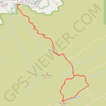
Fat Man's Pass Loop via Mormon, National and Hidden Valley Trails
Interactive trail map
Thank you for supporting this site ❤️
Make a donation
Make a donation
Gear up for your next adventure:
As an Amazon Associate, this site earns from qualifying purchases at no extra cost to you.
Trail profile
- Distance: 3.7 mi
- Elevation gain: 879 ft
- Maximum elevation: 2,116 ft
- Elevation loss: 879 ft
- Minimum elevation: 1,283 ft
Thank you for supporting this site ❤️
Make a donation
Make a donation
Gear up for your next adventure:
As an Amazon Associate, this site earns from qualifying purchases at no extra cost to you.
About this trail
Name: Fat Man's Pass Loop via Mormon, National and Hidden Valley Trails trail, distance, elevation, map, profile, GPS track
Coordinates: 33.35061 -112.03144 33.36650 -112.01768
Topography: Phoenix topographic map, elevation, terrain
Thank you for supporting this site ❤️
Make a donation
Make a donation
Gear up for your next adventure:
As an Amazon Associate, this site earns from qualifying purchases at no extra cost to you.