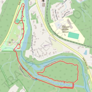
Pawpaw Crossing trail and surrounding paths
- Distance: 2.6 mi
- Elevation gain: 85 ft
- Maximum elevation: 617 ft
- Elevation loss: 98 ft
- Minimum elevation: 571 ft
- Moving time: 58 m 9 s
- Moving speed: 2.7 mph
- Maximum speed: 4.0 mph
- Total time: 59 m 16 s
- Global speed: 2.6 mph
Interactive trail map
Trail profile
- Distance: 2.6 mi
- Elevation gain: 85 ft
- Maximum elevation: 617 ft
- Elevation loss: 98 ft
- Minimum elevation: 571 ft
- Moving time: 58 m 9 s
- Moving speed: 2.7 mph
- Maximum speed: 4.0 mph
- Total time: 59 m 16 s
- Global speed: 2.6 mph
About this trail
Name: Pawpaw Crossing trail and surrounding paths trail, distance, elevation, map, profile, GPS track
Start: Outer Loop, Batavia Township, Clermont County, Ohio, 45103, United States (39.06728 -84.18811)
End: Outer Loop, Batavia Township, Clermont County, Ohio, 45103, United States (39.06736 -84.18778)
Coordinates: 39.06352 -84.18819 39.07165 -84.18024
Topography: Clermont County topographic map, elevation, terrain