Make a donation
Gear up for your next adventure:
As an Amazon Associate, this site earns from qualifying purchases at no extra cost to you.
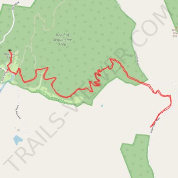
Cumberland Trail, Head of the Sequatchie River and Devilstep Cave
- Distance: 7.4 mi
- Elevation gain: 1,900 ft
- Maximum elevation: 2,251 ft
- Elevation loss: 1,900 ft
- Minimum elevation: 1,073 ft
- Moving time: 3 h 17 m
- Moving speed: 2.3 mph
- Maximum speed: 3.7 mph
- Total time: 4 h 15 m
- Global speed: 1.7 mph
Interactive trail map
Make a donation
Gear up for your next adventure:
As an Amazon Associate, this site earns from qualifying purchases at no extra cost to you.
Trail profile
- Distance: 7.4 mi
- Elevation gain: 1,900 ft
- Maximum elevation: 2,251 ft
- Elevation loss: 1,900 ft
- Minimum elevation: 1,073 ft
- Moving time: 3 h 17 m
- Moving speed: 2.3 mph
- Maximum speed: 3.7 mph
- Total time: 4 h 15 m
- Global speed: 1.7 mph
Make a donation
Gear up for your next adventure:
As an Amazon Associate, this site earns from qualifying purchases at no extra cost to you.
About this trail
Name: Cumberland Trail, Head of the Sequatchie River and Devilstep Cave trail, distance, elevation, map, profile, GPS track
Start: Park Road, Cumberland County, East Tennessee, Tennessee, United States (35.79334 -85.00880)
End: Park Road, Cumberland County, East Tennessee, Tennessee, United States (35.79290 -85.00904)
Coordinates: 35.78554 -85.00909 35.79578 -84.98189
Topography: Cumberland County topographic map, elevation, terrain
Make a donation
Gear up for your next adventure:
As an Amazon Associate, this site earns from qualifying purchases at no extra cost to you.
Other hiking, mountain biking, running and outdoor activity trails
Click on a trail to view its statistics, map and profile.
Cumberland Trail from Head of Sequatchie to Stinging Fork via Hinch Mountain
United States > Tennessee > Cumberland County
Distance: 17.5 mi • Elevation gain: 3,642 ft • Maximum elevation: 2,510 ft
CT - Brady Mountain & Black Mountain
United States > Tennessee > Cumberland County
Distance: 14.7 mi • Elevation gain: 2,743 ft • Maximum elevation: 2,910 ft