Thank you for supporting this site ❤️
Make a donation
Make a donation
Gear up for your next adventure:
As an Amazon Associate, this site earns from qualifying purchases at no extra cost to you.
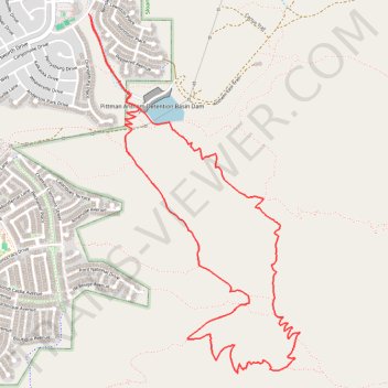
Park Peak
- Distance: 5.2 mi
- Elevation gain: 902 ft
- Maximum elevation: 3,789 ft
- Elevation loss: 906 ft
- Minimum elevation: 2,976 ft
- Moving time: 2 h 1 m
- Moving speed: 2.6 mph
- Maximum speed: 3.8 mph
- Total time: 2 h 29 m
- Global speed: 2.1 mph
Interactive trail map
Thank you for supporting this site ❤️
Make a donation
Make a donation
Gear up for your next adventure:
As an Amazon Associate, this site earns from qualifying purchases at no extra cost to you.
Trail profile
- Distance: 5.2 mi
- Elevation gain: 902 ft
- Maximum elevation: 3,789 ft
- Elevation loss: 906 ft
- Minimum elevation: 2,976 ft
- Moving time: 2 h 1 m
- Moving speed: 2.6 mph
- Maximum speed: 3.8 mph
- Total time: 2 h 29 m
- Global speed: 2.1 mph
Thank you for supporting this site ❤️
Make a donation
Make a donation
Gear up for your next adventure:
As an Amazon Associate, this site earns from qualifying purchases at no extra cost to you.
About this trail
Name: Park Peak trail, distance, elevation, map, profile, GPS track
End: Anthem East Trail, Anthem, Henderson, Clark County, Nevada, United States (35.94506 -115.08137)
Coordinates: 35.92357 -115.08154 35.94514 -115.06582
Topography: Henderson topographic map, elevation, terrain
Thank you for supporting this site ❤️
Make a donation
Make a donation
Gear up for your next adventure:
As an Amazon Associate, this site earns from qualifying purchases at no extra cost to you.