Prairie Creek park
- Distance: 0.4 mi
- Elevation gain: 10 ft
- Maximum elevation: 617 ft
- Elevation loss: 20 ft
- Minimum elevation: 597 ft
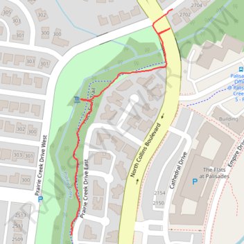
Interactive trail map
Trail profile
- Distance: 0.4 mi
- Elevation gain: 10 ft
- Maximum elevation: 617 ft
- Elevation loss: 20 ft
- Minimum elevation: 597 ft
About this trail
Name: Prairie Creek park trail, distance, elevation, map, profile, GPS track
Start: Huck Finn Trail, Richardson, Collin County, Texas, 75080, United States (32.98641 -96.71809)
Coordinates: 32.98641 -96.71809 32.99054 -96.71589
Topography: Richardson topographic map, elevation, terrain