Make a donation
Gear up for your next adventure:
As an Amazon Associate, this site earns from qualifying purchases at no extra cost to you.
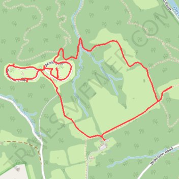
Susquehanna State Park Campground trails
- Distance: 2.9 mi
- Elevation gain: 217 ft
- Maximum elevation: 344 ft
- Elevation loss: 217 ft
- Minimum elevation: 197 ft
- Moving time: 1 h 36 m
- Moving speed: 1.8 mph
- Maximum speed: 2.9 mph
- Total time: 1 h 57 m
- Global speed: 1.5 mph
Interactive trail map
Make a donation
Gear up for your next adventure:
As an Amazon Associate, this site earns from qualifying purchases at no extra cost to you.
Trail profile
- Distance: 2.9 mi
- Elevation gain: 217 ft
- Maximum elevation: 344 ft
- Elevation loss: 217 ft
- Minimum elevation: 197 ft
- Moving time: 1 h 36 m
- Moving speed: 1.8 mph
- Maximum speed: 2.9 mph
- Total time: 1 h 57 m
- Global speed: 1.5 mph
Make a donation
Gear up for your next adventure:
As an Amazon Associate, this site earns from qualifying purchases at no extra cost to you.
About this trail
Name: Susquehanna State Park Campground trails trail, distance, elevation, map, profile, GPS track
Start: Ivy Branch Trail (orange), Harford County, Maryland, 21094, United States (39.60756 -76.15930)
End: Ivy Branch Trail (orange), Harford County, Maryland, 21094, United States (39.60752 -76.15932)
Coordinates: 39.60752 -76.16816 39.61458 -76.15329
Topography: Harford County topographic map, elevation, terrain
Make a donation
Gear up for your next adventure:
As an Amazon Associate, this site earns from qualifying purchases at no extra cost to you.