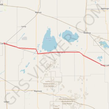
Import a GPX file

Lanigan - Foam Lake

#Bike #Lanigan #Foam

  • Distance: 70.2 mi
  • Elevation gain: 600 ft
  • Maximum elevation: 1,854 ft
  • Elevation loss: 525 ft
  • Minimum elevation: 1,703 ft

Interactive trail map

Trail profile

  • Distance: 70.2 mi
  • Elevation gain: 600 ft
  • Maximum elevation: 1,854 ft
  • Elevation loss: 525 ft
  • Minimum elevation: 1,703 ft

About this trail

Name: Lanigan - Foam Lake trail, distance, elevation, map, profile, GPS track

Start: Downing Drive, Lanigan, Saskatchewan, S0K 2M0, Canada (51.85079 -105.02121)

End: Foam Lake, Saskatchewan, S0A 1A0, Canada (51.63736 -103.53713)

Coordinates: 51.63736 -105.02883 51.85082 -103.53695

Other hiking, mountain biking, running and outdoor activity trails

Click on a trail to view its statistics, map and profile.

Foam Lake - Yorkton

Canada > Saskatchewan > Foam Lake No. 276 > Foam Lake

#Bike #Foam #Yorkton

Distance: 56.6 mi • Elevation gain: 358 ft • Maximum elevation: 1,847 ft

Saskatoon - Lanigan

Canada > Saskatchewan > Saskatoon

#Bike #Saskatoon #Lanigan

Distance: 80.5 mi • Elevation gain: 774 ft • Maximum elevation: 1,834 ft

Gear up for your next adventure:

🛰️Satellite Messengers - Emergency SOS and two-way messaging for off-grid adventures
🛠️Backpacking Tool Kit - Essential toolkit for outdoor repairs
🏔️Mountain Trail Maps - High‑detail maps for popular peaks
🎒Trekking Poles - Sturdy poles for balance and stability on rough terrain
🗻Climbing Gear Basics - Essential gear for beginner climbers

As an Amazon Associate, this site earns from qualifying purchases at no extra cost to you.