Make a donation
Gear up for your next adventure:
As an Amazon Associate, this site earns from qualifying purchases at no extra cost to you.
Quail Creek bike trail and beach
- Distance: 2.3 mi
- Elevation gain: 262 ft
- Maximum elevation: 3,133 ft
- Elevation loss: 253 ft
- Minimum elevation: 2,982 ft
- Moving time: 1 h 5 m
- Moving speed: 2.1 mph
- Maximum speed: 3.5 mph
- Total time: 1 h 9 m
- Global speed: 2.0 mph
Interactive trail map
Make a donation
Gear up for your next adventure:
As an Amazon Associate, this site earns from qualifying purchases at no extra cost to you.
Trail profile
- Distance: 2.3 mi
- Elevation gain: 262 ft
- Maximum elevation: 3,133 ft
- Elevation loss: 253 ft
- Minimum elevation: 2,982 ft
- Moving time: 1 h 5 m
- Moving speed: 2.1 mph
- Maximum speed: 3.5 mph
- Total time: 1 h 9 m
- Global speed: 2.0 mph
Make a donation
Gear up for your next adventure:
As an Amazon Associate, this site earns from qualifying purchases at no extra cost to you.
About this trail
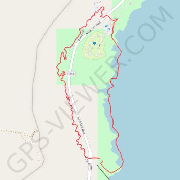
Name: Quail Creek bike trail and beach trail, distance, elevation, map, profile, GPS track
Start: North 5300 West, Hurricane, Washington County, Utah, United States (37.17891 -113.39498)
End: North 5300 West, Hurricane, Washington County, Utah, United States (37.17909 -113.39521)
Coordinates: 37.17809 -113.39876 37.18897 -113.39329
Topography: Washington County topographic map, elevation, terrain
Make a donation
Gear up for your next adventure:
As an Amazon Associate, this site earns from qualifying purchases at no extra cost to you.