Thank you for supporting this site ❤️
Make a donation
Make a donation
Gear up for your next adventure:
As an Amazon Associate, this site earns from qualifying purchases at no extra cost to you.
2024-10-07 23:16:21
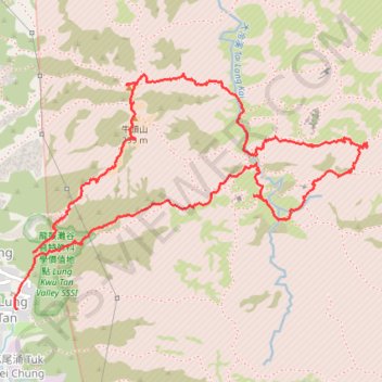
- Distance: 4.1 mi
- Elevation gain: 1,401 ft
- Maximum elevation: 965 ft
- Elevation loss: 1,421 ft
- Minimum elevation: 10 ft
- Moving time: 3 h 16 m
- Moving speed: 1.2 mph
- Maximum speed: 5.3 mph
- Total time: 5 h 35 m
- Global speed: 0.7 mph
Interactive trail map
Thank you for supporting this site ❤️
Make a donation
Make a donation
Gear up for your next adventure:
As an Amazon Associate, this site earns from qualifying purchases at no extra cost to you.
Trail profile
- Distance: 4.1 mi
- Elevation gain: 1,401 ft
- Maximum elevation: 965 ft
- Elevation loss: 1,421 ft
- Minimum elevation: 10 ft
- Moving time: 3 h 16 m
- Moving speed: 1.2 mph
- Maximum speed: 5.3 mph
- Total time: 5 h 35 m
- Global speed: 0.7 mph
Thank you for supporting this site ❤️
Make a donation
Make a donation
Gear up for your next adventure:
As an Amazon Associate, this site earns from qualifying purchases at no extra cost to you.
About this trail
Name: 2024-10-07 23:16:21 trail, distance, elevation, map, profile, GPS track
Coordinates: 22.38953 113.92264 22.40000 113.93955
Thank you for supporting this site ❤️
Make a donation
Make a donation
Gear up for your next adventure:
As an Amazon Associate, this site earns from qualifying purchases at no extra cost to you.
Other hiking, mountain biking, running and outdoor activity trails
Click on a trail to view its statistics, map and profile.
2024 4TUL Half Loop Final
China > Hong Kong > Tsuen Wan District > Chuen Lung Village > Chuen Lung Cha Tau Wo
Distance: 55.3 mi • Elevation gain: 7,438 ft • Maximum elevation: 1,755 ft