Thank you for supporting this site ❤️
Make a donation
Make a donation
Gear up for your next adventure:
As an Amazon Associate, this site earns from qualifying purchases at no extra cost to you.
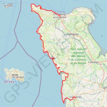
GR223 - Cherbourg à Coutances
https://en-hk.gps-viewer.com/track-217rr/GR223-Cherbourg-à-Coutances/
- Distance: 125.1 mi
- Elevation gain: 6,850 ft
- Maximum elevation: 453 ft
- Elevation loss: 6,703 ft
- Minimum elevation: -3 ft
Interactive trail map
Thank you for supporting this site ❤️
Make a donation
Make a donation
Gear up for your next adventure:
As an Amazon Associate, this site earns from qualifying purchases at no extra cost to you.
Trail profile
- Distance: 125.1 mi
- Elevation gain: 6,850 ft
- Maximum elevation: 453 ft
- Elevation loss: 6,703 ft
- Minimum elevation: -3 ft
Thank you for supporting this site ❤️
Make a donation
Make a donation
Gear up for your next adventure:
As an Amazon Associate, this site earns from qualifying purchases at no extra cost to you.
About this trail
Name: GR223 - Cherbourg à Coutances trail, distance, elevation, map, profile, GPS track
Coordinates: 49.00176 -1.94747 49.72691 -1.44202
Thank you for supporting this site ❤️
Make a donation
Make a donation
Gear up for your next adventure:
As an Amazon Associate, this site earns from qualifying purchases at no extra cost to you.