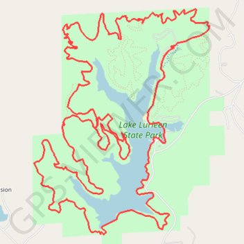
Lake Lurleen MTB Loop
Mountain Bike loop around the Lake Lurleen. Lake Lurleen State Park. #MTB #Loop #Lake #Forest #Nature
- Distance: 13.7 mi
- Elevation gain: 1,250 ft
- Maximum elevation: 430 ft
- Elevation loss: 1,250 ft
- Minimum elevation: 210 ft
- Moving time: 2 h 50 m
- Moving speed: 4.8 mph
- Maximum speed: 25.5 mph
- Total time: 3 h 37 m
- Global speed: 3.8 mph
Interactive trail map
Trail profile
- Distance: 13.7 mi
- Elevation gain: 1,250 ft
- Maximum elevation: 430 ft
- Elevation loss: 1,250 ft
- Minimum elevation: 210 ft
- Moving time: 2 h 50 m
- Moving speed: 4.8 mph
- Maximum speed: 25.5 mph
- Total time: 3 h 37 m
- Global speed: 3.8 mph
About this trail
Name: Lake Lurleen MTB Loop trail, distance, elevation, map, profile, GPS track
Start: Lakeside Trail, Tuscaloosa County, Alabama, United States (33.29712 -87.67710)
End: Lakeside Trail, Tuscaloosa County, Alabama, United States (33.29716 -87.67705)
Coordinates: 33.28559 -87.69485 33.31351 -87.66882
Topography: Tuscaloosa County topographic map, elevation, terrain