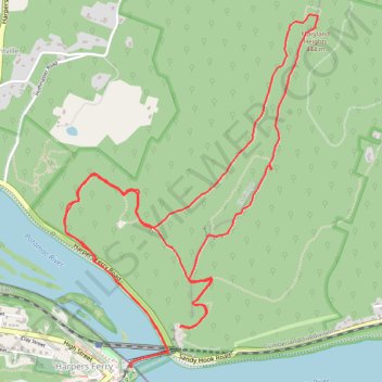
Maryland Heights Loop
Interactive trail map
Trail profile
- Distance: 6.2 mi
- Elevation gain: 1,598 ft
- Maximum elevation: 1,444 ft
- Elevation loss: 1,598 ft
- Minimum elevation: 246 ft
- Moving time: 2 h 24 m
- Moving speed: 2.6 mph
- Maximum speed: 4.7 mph
- Total time: 2 h 47 m
- Global speed: 2.2 mph
About this trail
Name: Maryland Heights Loop trail, distance, elevation, map, profile, GPS track
Coordinates: 39.32330 -77.73333 39.34170 -77.71620
Topography: Jefferson County topographic map, elevation, terrain
Other hiking, mountain biking, running and outdoor activity trails
Click on a trail to view its statistics, map and profile.
Maryland Heights Loop Trail in Harpers Ferry National Historical Park
United States > West Virginia > Jefferson County > Harpers Ferry
The Maryland Heights Loop in Harpers Ferry National Historical Park offers hikers a rewarding journey through rich Civil War history and breathtaking natural vistas. As you ascend the trail, remnants of military fortifications like the Naval Battery and the Stone Fort provide a tangible connection to the past.…
Distance: 6.2 mi • Elevation gain: 1,640 ft • Maximum elevation: 1,444 ft
Maryland Heights Loop via Stone Fort Trail in Harpers Ferry National Historical Park
United States > West Virginia > Jefferson County > Harpers Ferry
The Maryland Heights Loop offers a truly delightful hiking experience. As you ascend, you're treated to breathtaking views of the Potomac and Shenandoah rivers, framed by the lush colors of nature. The trail, rich in Civil War history, meanders past the remnants of the historic Stone Fort, inviting you to…
Distance: 6.2 mi • Elevation gain: 1,667 ft • Maximum elevation: 1,444 ft
Maryland Heights via Naval Battery and Overlook Cliff Trail in Harpers Ferry National Historical Park
United States > West Virginia > Jefferson County > Harpers Ferry
The hike to Maryland Heights via the Naval Battery and Overlook Cliff Trail offers a delightful blend of breathtaking views and rich history. As you ascend, you’ll encounter remnants of Civil War fortifications, which serve as a poignant reminder of the area’s past, while the stunning panoramas of the…
Distance: 4.2 mi • Elevation gain: 1,171 ft • Maximum elevation: 968 ft