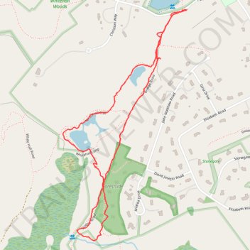
Tamarack Farms
- Distance: 1.8 mi
- Elevation gain: 157 ft
- Maximum elevation: 440 ft
- Elevation loss: 154 ft
- Minimum elevation: 344 ft
- Moving time: 53 m 6 s
- Moving speed: 2.1 mph
- Maximum speed: 3.9 mph
- Total time: 55 m 12 s
- Global speed: 2.0 mph
Interactive trail map
Trail profile
- Distance: 1.8 mi
- Elevation gain: 157 ft
- Maximum elevation: 440 ft
- Elevation loss: 154 ft
- Minimum elevation: 344 ft
- Moving time: 53 m 6 s
- Moving speed: 2.1 mph
- Maximum speed: 3.9 mph
- Total time: 55 m 12 s
- Global speed: 2.0 mph
About this trail
Name: Tamarack Farms trail, distance, elevation, map, profile, GPS track
Coordinates: 42.20412 -71.58579 42.21353 -71.57896
Topography: Middlesex County topographic map, elevation, terrain
Other hiking, mountain biking, running and outdoor activity trails
Click on a trail to view its statistics, map and profile.
Loop in Eastern Mass involving various rail trails
United States > Massachusetts > Middlesex County > Newton
Distance: 126.6 mi • Elevation gain: 6,365 ft • Maximum elevation: 636 ft