Thank you for supporting this site ❤️
Make a donation
Make a donation
Gear up for your next adventure:
As an Amazon Associate, this site earns from qualifying purchases at no extra cost to you.
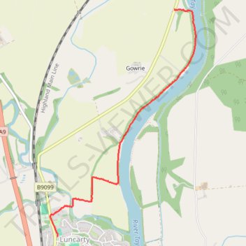
Exploring from Luncarty to Stanley along River Tay
- Distance: 2.0 mi
- Elevation gain: 121 ft
- Maximum elevation: 151 ft
- Elevation loss: 66 ft
- Minimum elevation: 43 ft
- Moving time: 27 m 23 s
- Moving speed: 4.4 mph
- Maximum speed: 8.8 mph
- Total time: 30 m 25 s
- Global speed: 4.0 mph
Interactive trail map
Thank you for supporting this site ❤️
Make a donation
Make a donation
Gear up for your next adventure:
As an Amazon Associate, this site earns from qualifying purchases at no extra cost to you.
Trail profile
- Distance: 2.0 mi
- Elevation gain: 121 ft
- Maximum elevation: 151 ft
- Elevation loss: 66 ft
- Minimum elevation: 43 ft
- Moving time: 27 m 23 s
- Moving speed: 4.4 mph
- Maximum speed: 8.8 mph
- Total time: 30 m 25 s
- Global speed: 4.0 mph
Thank you for supporting this site ❤️
Make a donation
Make a donation
Gear up for your next adventure:
As an Amazon Associate, this site earns from qualifying purchases at no extra cost to you.
About this trail
Name: Exploring from Luncarty to Stanley along River Tay trail, distance, elevation, map, profile, GPS track
Coordinates: 56.45308 -3.47091 56.47212 -3.44887
Thank you for supporting this site ❤️
Make a donation
Make a donation
Gear up for your next adventure:
As an Amazon Associate, this site earns from qualifying purchases at no extra cost to you.