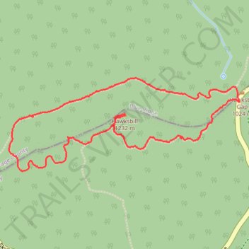
Hawksbill Loop Trail
Via Appalachian Trail in Shenandoah National Park #Hiking #Loop #Forest #Rock #Overlook
- Distance: 2.8 mi
- Elevation gain: 738 ft
- Maximum elevation: 3,993 ft
- Elevation loss: 738 ft
- Minimum elevation: 3,343 ft
- Moving time: 1 h 29 m
- Moving speed: 1.9 mph
- Maximum speed: 3.3 mph
- Total time: 1 h 57 m
- Global speed: 1.5 mph
Interactive trail map
Trail profile
- Distance: 2.8 mi
- Elevation gain: 738 ft
- Maximum elevation: 3,993 ft
- Elevation loss: 738 ft
- Minimum elevation: 3,343 ft
- Moving time: 1 h 29 m
- Moving speed: 1.9 mph
- Maximum speed: 3.3 mph
- Total time: 1 h 57 m
- Global speed: 1.5 mph
About this trail
Name: Hawksbill Loop Trail trail, distance, elevation, map, profile, GPS track
Start: Hawksbill Gap Parking, Skyline Drive, Madison County, Virginia, United States (38.55606 -78.38667)
End: Hawksbill Gap Parking, Skyline Drive, Madison County, Virginia, United States (38.55608 -78.38670)
Coordinates: 38.55209 -78.40363 38.55744 -78.38667
Topography: Madison County topographic map, elevation, terrain
Other hiking, mountain biking, running and outdoor activity trails
Click on a trail to view its statistics, map and profile.
Hawksbill Trail in Shenandoah National Park
United States > Virginia > Madison County
Hiking the Hawksbill Trail is a truly rewarding experience, leading you through lush forests to the summit of Shenandoah National Park's highest peak. Along the way, you’ll encounter stunning views of the Shenandoah Valley and the majestic Blue Ridge Mountains, especially from the rocky outcrops and the…
Distance: 1.7 mi • Elevation gain: 636 ft • Maximum elevation: 3,993 ft
Hawksbill Loop Trail via Appalachian Trail in Shenandoah National Park
United States > Virginia > Madison County
The Hawksbill Loop Trail in Shenandoah National Park offers hikers a journey through lush forests and rocky terrains, culminating at the park's highest peak, Hawksbill Summit. From the summit's viewing platform, one can enjoy panoramic vistas of the Shenandoah Valley, the Blue Ridge Mountains, and the Virginia…
Distance: 2.7 mi • Elevation gain: 732 ft • Maximum elevation: 3,993 ft
Loop hike to Hawksbill via Appalachian Trail in Shenandoah National Park
United States > Virginia > Madison County
Hiking the Hawksbill is an exhilarating experience, where you’re rewarded with breathtaking 360-degree views from the summit, showcasing the vastness of the Shenandoah Valley and the Blue Ridge Mountains. Along the trail, you'll encounter vibrant wildflowers, rocky outcrops, and the occasional glimpse of…
Distance: 2.8 mi • Elevation gain: 725 ft • Maximum elevation: 3,993 ft
Hawksbill Summit via Lower Hawksbill Trail in Shenandoah National Park
United States > Virginia > Madison County
The hike to Hawksbill Summit via the Lower Hawksbill Trail is a moderately challenging hike through a lush, forested path that eventually opens up to stunning panoramic views from the highest peak in Shenandoah National Park. Along the route, hikers navigate rocky terrain, pass through shaded woodlands lined…
Distance: 1.6 mi • Elevation gain: 623 ft • Maximum elevation: 3,993 ft
Loop hike via Weakley Hollow, White Oak Canyon, Hawksbill, Appalachian Trailand Old Rag in Shenandoah National Park
United States > Virginia > Madison County
Distance: 21.8 mi • Elevation gain: 4,744 ft • Maximum elevation: 3,993 ft