神仙井坑 狗仔坑 較水寮坑
- Distance: 4.3 mi
- Elevation gain: 869 ft
- Maximum elevation: 430 ft
- Elevation loss: 863 ft
- Minimum elevation: -3 ft
- Moving time: 4 h 3 m
- Moving speed: 1.1 mph
- Maximum speed: 3.8 mph
- Total time: 6 h 24 m
- Global speed: 0.7 mph
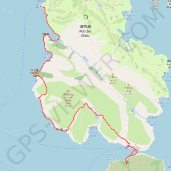
Interactive trail map
Trail profile
- Distance: 4.3 mi
- Elevation gain: 869 ft
- Maximum elevation: 430 ft
- Elevation loss: 863 ft
- Minimum elevation: -3 ft
- Moving time: 4 h 3 m
- Moving speed: 1.1 mph
- Maximum speed: 3.8 mph
- Total time: 6 h 24 m
- Global speed: 0.7 mph
About this trail
Name: 神仙井坑 狗仔坑 較水寮坑 trail, distance, elevation, map, profile, GPS track
Start: 玉帶橋, Yim Tin Tsai, Sai Kung District, New Territories, Hong Kong, China (22.36538 114.30476)
Coordinates: 22.33986 114.30361 22.36538 114.32174
Other hiking, mountain biking, running and outdoor activity trails
Click on a trail to view its statistics, map and profile.
城門~北潭坳
China > Hong Kong > Tsuen Wan District > Kwai Chung > Lower Shing Mun Village
ShingMunReservoir~PakTamAu
Distance: 23.3 mi • Elevation gain: 7,156 ft • Maximum elevation: 1,808 ft
大往灣坑 泥鯭埔坑
China > Hong Kong > Sai Kung District > Yim Tin Tsai
Hong Kong Hike
Distance: 5.4 mi • Elevation gain: 1,234 ft • Maximum elevation: 482 ft
麦理浩径
China > Hong Kong > Sai Kung District > Tsak Yue Wu
北潭涌至屯门
Distance: 61.3 mi • Elevation gain: 16,886 ft • Maximum elevation: 3,031 ft