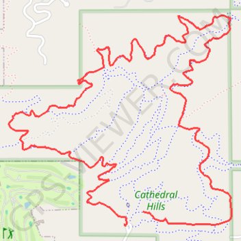
Cathedral Hills
- Distance: 4.0 mi
- Elevation gain: 745 ft
- Maximum elevation: 1,493 ft
- Elevation loss: 761 ft
- Minimum elevation: 1,138 ft
- Moving time: 51 m 13 s
- Moving speed: 4.7 mph
- Maximum speed: 12.4 mph
- Total time: 54 m 20 s
- Global speed: 4.4 mph
Interactive trail map
Trail profile
- Distance: 4.0 mi
- Elevation gain: 745 ft
- Maximum elevation: 1,493 ft
- Elevation loss: 761 ft
- Minimum elevation: 1,138 ft
- Moving time: 51 m 13 s
- Moving speed: 4.7 mph
- Maximum speed: 12.4 mph
- Total time: 54 m 20 s
- Global speed: 4.4 mph
About this trail
Name: Cathedral Hills trail, distance, elevation, map, profile, GPS track
Start: Backside Loop Trail, Josephine County, Oregon, 97527, United States (42.39462 -123.33268)
Coordinates: 42.39395 -123.34145 42.40409 -123.32693
Topography: Josephine County topographic map, elevation, terrain