Import a GPX file

Bow Falls Viewpoint

Bow River. Banff National Park. #Hiking #Banff

  • Distance: 1.7 mi
  • Elevation gain: 148 ft
  • Maximum elevation: 4,554 ft
  • Elevation loss: 148 ft
  • Minimum elevation: 4,465 ft

Interactive trail map

Trail profile

  • Distance: 1.7 mi
  • Elevation gain: 148 ft
  • Maximum elevation: 4,554 ft
  • Elevation loss: 148 ft
  • Minimum elevation: 4,465 ft

About this trail

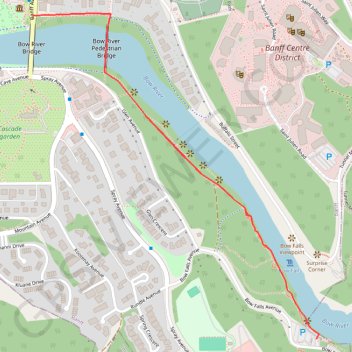
Name: Bow Falls Viewpoint trail, distance, elevation, map, profile, GPS track

Start: 90, Banff Avenue, Downtown District, Banff, Alberta, T1L 1B7, Canada (51.17359 -115.57114)

End: 90, Banff Avenue, Downtown District, Banff, Alberta, T1L 1C7, Canada (51.17359 -115.57114)

Coordinates: 51.16551 -115.57114 51.17365 -115.55975

Other hiking, mountain biking, running and outdoor activity trails

Click on a trail to view its statistics, map and profile.

Bow Falls - Bow River - Banff

Canada > Alberta > Improvement District No. 9

Banff National Park. #Hiking #Trail #Banff

Distance: 4.9 mi • Elevation gain: 856 ft • Maximum elevation: 5,128 ft

Gear up for your next adventure:

🔋Solar Power Banks - Keep your GPS and phone charged in remote wilderness areas
🪶Thermal Camp Blanket - Extra warmth for cold nights
🥇GPS Hiking Watch - Multi‑sport GPS watch with navigation and trail tracking
🛰️Handheld GPS Units - Professional satellite navigators for precise backcountry mapping
🧭Orienteering Set - Complete compass and map reading kit

As an Amazon Associate, this site earns from qualifying purchases at no extra cost to you.