Thank you for supporting this site ❤️
Make a donation
Make a donation
Gear up for your next adventure:
As an Amazon Associate, this site earns from qualifying purchases at no extra cost to you.
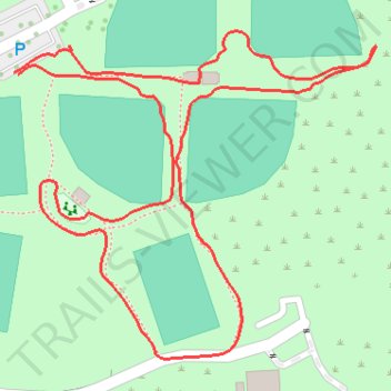
Santa Clarita Central Park loop walk
- Distance: 1.0 mi
- Elevation gain: 49 ft
- Maximum elevation: 1,270 ft
- Elevation loss: 49 ft
- Minimum elevation: 1,234 ft
- Moving time: 25 m 57 s
- Moving speed: 2.3 mph
- Maximum speed: 4.5 mph
- Total time: 33 m 14 s
- Global speed: 1.8 mph
Interactive trail map
Thank you for supporting this site ❤️
Make a donation
Make a donation
Gear up for your next adventure:
As an Amazon Associate, this site earns from qualifying purchases at no extra cost to you.
Trail profile
- Distance: 1.0 mi
- Elevation gain: 49 ft
- Maximum elevation: 1,270 ft
- Elevation loss: 49 ft
- Minimum elevation: 1,234 ft
- Moving time: 25 m 57 s
- Moving speed: 2.3 mph
- Maximum speed: 4.5 mph
- Total time: 33 m 14 s
- Global speed: 1.8 mph
Thank you for supporting this site ❤️
Make a donation
Make a donation
Gear up for your next adventure:
As an Amazon Associate, this site earns from qualifying purchases at no extra cost to you.
About this trail
Name: Santa Clarita Central Park loop walk trail, distance, elevation, map, profile, GPS track
Coordinates: 34.43207 -118.52160 34.43485 -118.51789
Topography: Santa Clarita topographic map, elevation, terrain
Thank you for supporting this site ❤️
Make a donation
Make a donation
Gear up for your next adventure:
As an Amazon Associate, this site earns from qualifying purchases at no extra cost to you.