Thank you for supporting this site ❤️
Make a donation
Make a donation
Gear up for your next adventure:
As an Amazon Associate, this site earns from qualifying purchases at no extra cost to you.
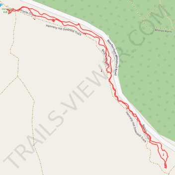
Hennessey Hill GPS Trace
- Distance: 1.5 mi
- Elevation gain: 341 ft
- Maximum elevation: 564 ft
- Elevation loss: 341 ft
- Minimum elevation: 223 ft
- Moving time: 49 m 12 s
- Moving speed: 1.8 mph
- Maximum speed: 6.0 mph
- Total time: 1 h 10 m
- Global speed: 1.3 mph
Interactive trail map
Thank you for supporting this site ❤️
Make a donation
Make a donation
Gear up for your next adventure:
As an Amazon Associate, this site earns from qualifying purchases at no extra cost to you.
Trail profile
- Distance: 1.5 mi
- Elevation gain: 341 ft
- Maximum elevation: 564 ft
- Elevation loss: 341 ft
- Minimum elevation: 223 ft
- Moving time: 49 m 12 s
- Moving speed: 1.8 mph
- Maximum speed: 6.0 mph
- Total time: 1 h 10 m
- Global speed: 1.3 mph
Thank you for supporting this site ❤️
Make a donation
Make a donation
Gear up for your next adventure:
As an Amazon Associate, this site earns from qualifying purchases at no extra cost to you.
About this trail
Name: Hennessey Hill GPS Trace trail, distance, elevation, map, profile, GPS track
Coordinates: -26.94348 152.86970 -26.93750 152.87640
Thank you for supporting this site ❤️
Make a donation
Make a donation
Gear up for your next adventure:
As an Amazon Associate, this site earns from qualifying purchases at no extra cost to you.
Other hiking, mountain biking, running and outdoor activity trails
Click on a trail to view its statistics, map and profile.
Woodford - Beerburrum West State Forest
Australia > Queensland > Woodford
#MTB #Loop #Beerburrum
Distance: 28.8 mi • Elevation gain: 2,287 ft • Maximum elevation: 696 ft