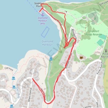
Diamond Harbour short circular track
- Distance: 1.7 mi
- Elevation gain: 285 ft
- Maximum elevation: 262 ft
- Elevation loss: 285 ft
- Minimum elevation: 0 ft
- Moving time: 46 m 54 s
- Moving speed: 2.2 mph
- Maximum speed: 3.1 mph
- Total time: 49 m 17 s
- Global speed: 2.1 mph
Interactive trail map
Trail profile
- Distance: 1.7 mi
- Elevation gain: 285 ft
- Maximum elevation: 262 ft
- Elevation loss: 285 ft
- Minimum elevation: 0 ft
- Moving time: 46 m 54 s
- Moving speed: 2.2 mph
- Maximum speed: 3.1 mph
- Total time: 49 m 17 s
- Global speed: 2.1 mph
About this trail
Name: Diamond Harbour short circular track trail, distance, elevation, map, profile, GPS track
Coordinates: -43.62948 172.73585 -43.62280 172.73988
Other hiking, mountain biking, running and outdoor activity trails
Click on a trail to view its statistics, map and profile.