Thank you for supporting this site ❤️
Make a donation
Make a donation
Gear up for your next adventure:
As an Amazon Associate, this site earns from qualifying purchases at no extra cost to you.
ACTIVE LOG
- Distance: 36.9 mi
- Elevation gain: 463 ft
- Maximum elevation: 292 ft
- Elevation loss: 469 ft
- Minimum elevation: 197 ft
- Moving time: 4 h 52 m
- Moving speed: 7.6 mph
- Maximum speed: 18.8 mph
- Total time: 5 h 7 m
- Global speed: 7.2 mph
Interactive trail map
Thank you for supporting this site ❤️
Make a donation
Make a donation
Gear up for your next adventure:
As an Amazon Associate, this site earns from qualifying purchases at no extra cost to you.
Trail profile
- Distance: 36.9 mi
- Elevation gain: 463 ft
- Maximum elevation: 292 ft
- Elevation loss: 469 ft
- Minimum elevation: 197 ft
- Moving time: 4 h 52 m
- Moving speed: 7.6 mph
- Maximum speed: 18.8 mph
- Total time: 5 h 7 m
- Global speed: 7.2 mph
Thank you for supporting this site ❤️
Make a donation
Make a donation
Gear up for your next adventure:
As an Amazon Associate, this site earns from qualifying purchases at no extra cost to you.
About this trail
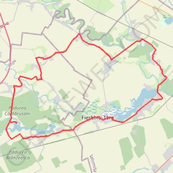
Name: ACTIVE LOG trail, distance, elevation, map, profile, GPS track
Start: Mănăstirea Căldărușani, DJ101C, Gruiu, Ilfov, 077116, Romania (44.67590 26.26657)
End: DJ101C, Gruiu, Ilfov, 077116, Romania (44.67709 26.25652)
Coordinates: 44.65984 26.25126 44.76753 26.48194
Thank you for supporting this site ❤️
Make a donation
Make a donation
Gear up for your next adventure:
As an Amazon Associate, this site earns from qualifying purchases at no extra cost to you.