Thank you for supporting this site ❤️
Make a donation
Make a donation
Gear up for your next adventure:
As an Amazon Associate, this site earns from qualifying purchases at no extra cost to you.
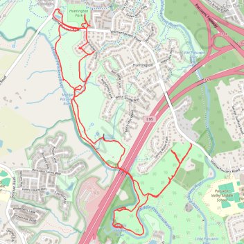
Savage Park
- Distance: 6.6 mi
- Elevation gain: 476 ft
- Maximum elevation: 344 ft
- Elevation loss: 476 ft
- Minimum elevation: 223 ft
- Moving time: 1 h 28 m
- Moving speed: 4.4 mph
- Maximum speed: 8.3 mph
- Total time: 1 h 30 m
- Global speed: 4.4 mph
Interactive trail map
Thank you for supporting this site ❤️
Make a donation
Make a donation
Gear up for your next adventure:
As an Amazon Associate, this site earns from qualifying purchases at no extra cost to you.
Trail profile
- Distance: 6.6 mi
- Elevation gain: 476 ft
- Maximum elevation: 344 ft
- Elevation loss: 476 ft
- Minimum elevation: 223 ft
- Moving time: 1 h 28 m
- Moving speed: 4.4 mph
- Maximum speed: 8.3 mph
- Total time: 1 h 30 m
- Global speed: 4.4 mph
Thank you for supporting this site ❤️
Make a donation
Make a donation
Gear up for your next adventure:
As an Amazon Associate, this site earns from qualifying purchases at no extra cost to you.
About this trail
Name: Savage Park trail, distance, elevation, map, profile, GPS track
Coordinates: 39.14190 -76.85033 39.16198 -76.83439
Topography: Howard County topographic map, elevation, terrain
Thank you for supporting this site ❤️
Make a donation
Make a donation
Gear up for your next adventure:
As an Amazon Associate, this site earns from qualifying purchases at no extra cost to you.
Other hiking, mountain biking, running and outdoor activity trails
Click on a trail to view its statistics, map and profile.
Loop Hike at Savage Park
United States > Maryland > Howard County > Savage
Distance: 3.1 mi • Elevation gain: 295 ft • Maximum elevation: 308 ft