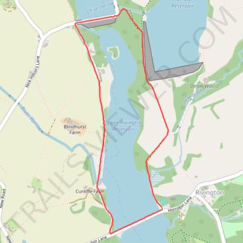
Upper Rivington Reservoir Loop
- Distance: 2.1 mi
- Elevation gain: 226 ft
- Maximum elevation: 561 ft
- Elevation loss: 226 ft
- Minimum elevation: 417 ft
- Moving time: 55 m 48 s
- Moving speed: 2.3 mph
- Maximum speed: 3.2 mph
- Total time: 56 m 24 s
- Global speed: 2.3 mph
Interactive trail map
Trail profile
- Distance: 2.1 mi
- Elevation gain: 226 ft
- Maximum elevation: 561 ft
- Elevation loss: 226 ft
- Minimum elevation: 417 ft
- Moving time: 55 m 48 s
- Moving speed: 2.3 mph
- Maximum speed: 3.2 mph
- Total time: 56 m 24 s
- Global speed: 2.3 mph
About this trail
Name: Upper Rivington Reservoir Loop trail, distance, elevation, map, profile, GPS track
Start: Horrobin Lane, Rivington, Chorley, Lancashire, England, BL6 7SE, United Kingdom (53.62474 -2.56957)
End: Horrobin Lane, Rivington, Chorley, Lancashire, England, PR6 9HE, United Kingdom (53.62462 -2.56948)
Coordinates: 53.62326 -2.57769 53.63573 -2.56898