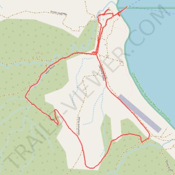
Loop hike on Santa Rosa Island
- Distance: 4.7 mi
- Elevation gain: 554 ft
- Maximum elevation: 459 ft
- Elevation loss: 548 ft
- Minimum elevation: 0 ft
- Moving time: 1 h 45 m
- Moving speed: 2.7 mph
- Maximum speed: 5.0 mph
- Total time: 2 h 7 m
- Global speed: 2.2 mph
Interactive trail map
Trail profile
- Distance: 4.7 mi
- Elevation gain: 554 ft
- Maximum elevation: 459 ft
- Elevation loss: 548 ft
- Minimum elevation: 0 ft
- Moving time: 1 h 45 m
- Moving speed: 2.7 mph
- Maximum speed: 5.0 mph
- Total time: 2 h 7 m
- Global speed: 2.2 mph
About this trail
Name: Loop hike on Santa Rosa Island trail, distance, elevation, map, profile, GPS track
Start: Airstrip Road, Santa Barbara County, California, United States (34.00853 -120.04711)
End: Airstrip Road, Santa Barbara County, California, United States (34.00779 -120.04826)
Coordinates: 33.98974 -120.06137 34.00853 -120.04399
Topography: Santa Barbara County topographic map, elevation, terrain