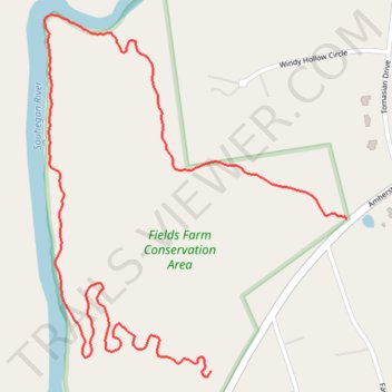
Fields Farm Conservation Area Trails
- Distance: 1.6 mi
- Elevation gain: 108 ft
- Maximum elevation: 318 ft
- Elevation loss: 121 ft
- Minimum elevation: 203 ft
- Moving time: 14 m 26 s
- Moving speed: 6.5 mph
- Maximum speed: 13.7 mph
- Total time: 16 m 30 s
- Global speed: 5.7 mph
Interactive trail map
Trail profile
- Distance: 1.6 mi
- Elevation gain: 108 ft
- Maximum elevation: 318 ft
- Elevation loss: 121 ft
- Minimum elevation: 203 ft
- Moving time: 14 m 26 s
- Moving speed: 6.5 mph
- Maximum speed: 13.7 mph
- Total time: 16 m 30 s
- Global speed: 5.7 mph
About this trail
Name: Fields Farm Conservation Area Trails trail, distance, elevation, map, profile, GPS track
Coordinates: 42.84107 -71.55866 42.84795 -71.55084
Topography: Hillsborough County topographic map, elevation, terrain
Other hiking, mountain biking, running and outdoor activity trails
Click on a trail to view its statistics, map and profile.
Fields Farms Conservation Area Trails
United States > New Hampshire > Hillsborough County > Merrimack
Distance: 6.9 mi • Elevation gain: 413 ft • Maximum elevation: 328 ft