Make a donation
Gear up for your next adventure:
As an Amazon Associate, this site earns from qualifying purchases at no extra cost to you.
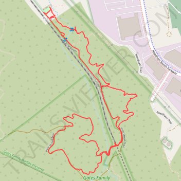
Pine Street Trail and Brady Trail Loop in Gates Family Wildlife Preserve
- Distance: 3.1 mi
- Elevation gain: 420 ft
- Maximum elevation: 1,729 ft
- Elevation loss: 420 ft
- Minimum elevation: 1,424 ft
- Moving time: 1 h 3 m
- Moving speed: 2.9 mph
- Maximum speed: 9.0 mph
- Total time: 1 h 7 m
- Global speed: 2.7 mph
Interactive trail map
Make a donation
Gear up for your next adventure:
As an Amazon Associate, this site earns from qualifying purchases at no extra cost to you.
Trail profile
- Distance: 3.1 mi
- Elevation gain: 420 ft
- Maximum elevation: 1,729 ft
- Elevation loss: 420 ft
- Minimum elevation: 1,424 ft
- Moving time: 1 h 3 m
- Moving speed: 2.9 mph
- Maximum speed: 9.0 mph
- Total time: 1 h 7 m
- Global speed: 2.7 mph
Make a donation
Gear up for your next adventure:
As an Amazon Associate, this site earns from qualifying purchases at no extra cost to you.
About this trail
Name: Pine Street Trail and Brady Trail Loop in Gates Family Wildlife Preserve trail, distance, elevation, map, profile, GPS track
Coordinates: 34.35153 -118.52176 34.36091 -118.51536
Topography: Santa Clarita topographic map, elevation, terrain
Make a donation
Gear up for your next adventure:
As an Amazon Associate, this site earns from qualifying purchases at no extra cost to you.
Other hiking, mountain biking, running and outdoor activity trails
Click on a trail to view its statistics, map and profile.
Pioneer Trail Loop Hike
United States > California > Los Angeles County > Santa Clarita > Elayon
Distance: 3.1 mi • Elevation gain: 305 ft • Maximum elevation: 1,499 ft