Thank you for supporting this site ❤️
Make a donation
Make a donation
Gear up for your next adventure:
As an Amazon Associate, this site earns from qualifying purchases at no extra cost to you.
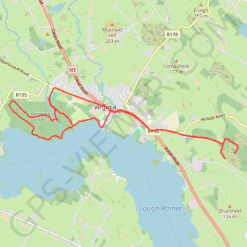
Virginia Evening Run
- Distance: 10.6 mi
- Elevation gain: 443 ft
- Maximum elevation: 384 ft
- Elevation loss: 443 ft
- Minimum elevation: 266 ft
- Moving time: 1 h 34 m
- Moving speed: 6.7 mph
- Maximum speed: 9.2 mph
- Total time: 1 h 35 m
- Global speed: 6.7 mph
Interactive trail map
Thank you for supporting this site ❤️
Make a donation
Make a donation
Gear up for your next adventure:
As an Amazon Associate, this site earns from qualifying purchases at no extra cost to you.
Trail profile
- Distance: 10.6 mi
- Elevation gain: 443 ft
- Maximum elevation: 384 ft
- Elevation loss: 443 ft
- Minimum elevation: 266 ft
- Moving time: 1 h 34 m
- Moving speed: 6.7 mph
- Maximum speed: 9.2 mph
- Total time: 1 h 35 m
- Global speed: 6.7 mph
Thank you for supporting this site ❤️
Make a donation
Make a donation
Gear up for your next adventure:
As an Amazon Associate, this site earns from qualifying purchases at no extra cost to you.
About this trail
Name: Virginia Evening Run trail, distance, elevation, map, profile, GPS track
Coordinates: 53.82396 -7.11735 53.83909 -7.03576
Thank you for supporting this site ❤️
Make a donation
Make a donation
Gear up for your next adventure:
As an Amazon Associate, this site earns from qualifying purchases at no extra cost to you.