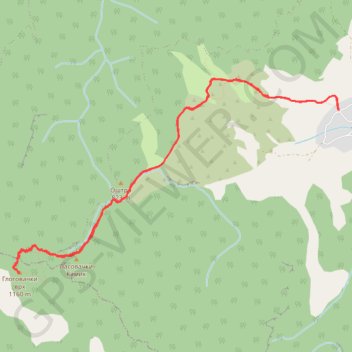
2021-02-21 17:38:06
- Distance: 6.7 mi
- Elevation gain: 2,208 ft
- Maximum elevation: 3,766 ft
- Elevation loss: 2,208 ft
- Minimum elevation: 1,588 ft
- Moving time: 3 h 7 m
- Moving speed: 2.2 mph
- Maximum speed: 3.9 mph
- Total time: 3 h 23 m
- Global speed: 2.0 mph
Interactive trail map
Trail profile
- Distance: 6.7 mi
- Elevation gain: 2,208 ft
- Maximum elevation: 3,766 ft
- Elevation loss: 2,208 ft
- Minimum elevation: 1,588 ft
- Moving time: 3 h 7 m
- Moving speed: 2.2 mph
- Maximum speed: 3.9 mph
- Total time: 3 h 23 m
- Global speed: 2.0 mph
About this trail
Name: 2021-02-21 17:38:06 trail, distance, elevation, map, profile, GPS track
Coordinates: 43.72894 22.16096 43.74797 22.20495