Make a donation
Gear up for your next adventure:
As an Amazon Associate, this site earns from qualifying purchases at no extra cost to you.
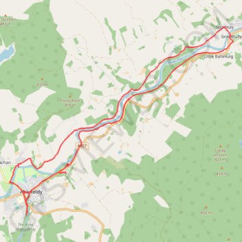
EMTB: Aberfeldy to Grandtully - Incl Rob Roy Way
Loop
- Distance: 12.5 mi
- Elevation gain: 876 ft
- Maximum elevation: 479 ft
- Elevation loss: 879 ft
- Minimum elevation: 233 ft
- Moving time: 1 h 32 m
- Moving speed: 8.1 mph
- Maximum speed: 23.2 mph
- Total time: 1 h 47 m
- Global speed: 7.0 mph
Interactive trail map
Make a donation
Gear up for your next adventure:
As an Amazon Associate, this site earns from qualifying purchases at no extra cost to you.
Trail profile
- Distance: 12.5 mi
- Elevation gain: 876 ft
- Maximum elevation: 479 ft
- Elevation loss: 879 ft
- Minimum elevation: 233 ft
- Moving time: 1 h 32 m
- Moving speed: 8.1 mph
- Maximum speed: 23.2 mph
- Total time: 1 h 47 m
- Global speed: 7.0 mph
Make a donation
Gear up for your next adventure:
As an Amazon Associate, this site earns from qualifying purchases at no extra cost to you.
About this trail
Name: EMTB: Aberfeldy to Grandtully - Incl Rob Roy Way trail, distance, elevation, map, profile, GPS track
Coordinates: 56.61350 -3.87485 56.65999 -3.77432
Make a donation
Gear up for your next adventure:
As an Amazon Associate, this site earns from qualifying purchases at no extra cost to you.
Other hiking, mountain biking, running and outdoor activity trails
Click on a trail to view its statistics, map and profile.
EMTB Gravel: Loch of Grandtully - Loop
United Kingdom > Scotland > Perth and Kinross > Aberfeldy
Around Loch Grandtully #UK #Perthshire #Aberfeldy #Griffin #Wood
Distance: 11.1 mi • Elevation gain: 1,119 ft • Maximum elevation: 1,499 ft