Thank you for supporting this site ❤️
Make a donation
Make a donation
Gear up for your next adventure:
As an Amazon Associate, this site earns from qualifying purchases at no extra cost to you.
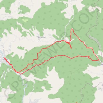
Девићи - Водопади Изубре
- Distance: 6.8 mi
- Elevation gain: 1,900 ft
- Maximum elevation: 3,839 ft
- Elevation loss: 1,900 ft
- Minimum elevation: 2,497 ft
- Moving time: 2 h 20 m
- Moving speed: 2.9 mph
- Maximum speed: 6.4 mph
- Total time: 2 h 20 m
- Global speed: 2.9 mph
Interactive trail map
Thank you for supporting this site ❤️
Make a donation
Make a donation
Gear up for your next adventure:
As an Amazon Associate, this site earns from qualifying purchases at no extra cost to you.
Trail profile
- Distance: 6.8 mi
- Elevation gain: 1,900 ft
- Maximum elevation: 3,839 ft
- Elevation loss: 1,900 ft
- Minimum elevation: 2,497 ft
- Moving time: 2 h 20 m
- Moving speed: 2.9 mph
- Maximum speed: 6.4 mph
- Total time: 2 h 20 m
- Global speed: 2.9 mph
Thank you for supporting this site ❤️
Make a donation
Make a donation
Gear up for your next adventure:
As an Amazon Associate, this site earns from qualifying purchases at no extra cost to you.
About this trail
Name: Девићи - Водопади Изубре trail, distance, elevation, map, profile, GPS track
Coordinates: 43.41699 20.37898 43.43234 20.42306
Thank you for supporting this site ❤️
Make a donation
Make a donation
Gear up for your next adventure:
As an Amazon Associate, this site earns from qualifying purchases at no extra cost to you.
Other hiking, mountain biking, running and outdoor activity trails
Click on a trail to view its statistics, map and profile.
2022_Yu
Slovenia > Ajdovščina > Žapuže
Distance: 1,526.9 mi • Elevation gain: 105,144 ft • Maximum elevation: 6,398 ft