Thank you for supporting this site ❤️
Make a donation
Make a donation
Gear up for your next adventure:
As an Amazon Associate, this site earns from qualifying purchases at no extra cost to you.
Nepean River - Great River Walk
Interactive trail map
Thank you for supporting this site ❤️
Make a donation
Make a donation
Gear up for your next adventure:
As an Amazon Associate, this site earns from qualifying purchases at no extra cost to you.
Trail profile
- Distance: 4.1 mi
- Elevation gain: 135 ft
- Maximum elevation: 105 ft
- Elevation loss: 131 ft
- Minimum elevation: 66 ft
- Moving time: 1 h 31 m
- Moving speed: 2.7 mph
- Maximum speed: 5.1 mph
- Total time: 1 h 35 m
- Global speed: 2.6 mph
Thank you for supporting this site ❤️
Make a donation
Make a donation
Gear up for your next adventure:
As an Amazon Associate, this site earns from qualifying purchases at no extra cost to you.
About this trail
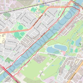
Name: Nepean River - Great River Walk trail, distance, elevation, map, profile, GPS track
Coordinates: -33.76534 150.65795 -33.74659 150.68267
Thank you for supporting this site ❤️
Make a donation
Make a donation
Gear up for your next adventure:
As an Amazon Associate, this site earns from qualifying purchases at no extra cost to you.
Other hiking, mountain biking, running and outdoor activity trails
Click on a trail to view its statistics, map and profile.