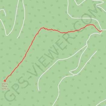
Shorty Peak up
Shorty Peak Trail
- Distance: 2.6 mi
- Elevation gain: 1,188 ft
- Maximum elevation: 6,424 ft
- Elevation loss: 30 ft
- Minimum elevation: 5,259 ft
- Moving time: 1 h 31 m
- Moving speed: 1.7 mph
- Maximum speed: 3.7 mph
- Total time: 1 h 43 m
- Global speed: 1.5 mph
Interactive trail map
Trail profile
- Distance: 2.6 mi
- Elevation gain: 1,188 ft
- Maximum elevation: 6,424 ft
- Elevation loss: 30 ft
- Minimum elevation: 5,259 ft
- Moving time: 1 h 31 m
- Moving speed: 1.7 mph
- Maximum speed: 3.7 mph
- Total time: 1 h 43 m
- Global speed: 1.5 mph
About this trail
Name: Shorty Peak up trail, distance, elevation, map, profile, GPS track
Start: 95 Italian Ridge, Boundary County, Idaho, United States (48.95325 -116.65069)
End: 95 Italian Ridge, Boundary County, Idaho, United States (48.94033 -116.68927)
Coordinates: 48.94017 -116.68927 48.95486 -116.65069
Topography: Boundary County topographic map, elevation, terrain