Thank you for supporting this site ❤️
Make a donation
Make a donation
Gear up for your next adventure:
As an Amazon Associate, this site earns from qualifying purchases at no extra cost to you.
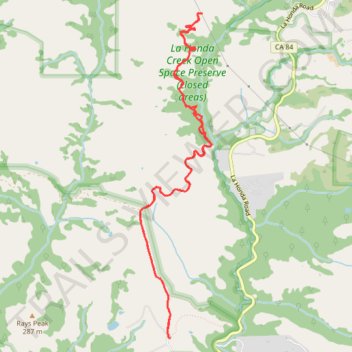
La Honda Creek Open Space - Harrington Creek Trail and Lonely Forest Trail
- Distance: 7.4 mi
- Elevation gain: 1,503 ft
- Maximum elevation: 1,152 ft
- Elevation loss: 1,499 ft
- Minimum elevation: 686 ft
- Moving time: 2 h 49 m
- Moving speed: 2.6 mph
- Maximum speed: 29.1 mph
- Total time: 3 h 9 m
- Global speed: 2.3 mph
Interactive trail map
Thank you for supporting this site ❤️
Make a donation
Make a donation
Gear up for your next adventure:
As an Amazon Associate, this site earns from qualifying purchases at no extra cost to you.
Trail profile
- Distance: 7.4 mi
- Elevation gain: 1,503 ft
- Maximum elevation: 1,152 ft
- Elevation loss: 1,499 ft
- Minimum elevation: 686 ft
- Moving time: 2 h 49 m
- Moving speed: 2.6 mph
- Maximum speed: 29.1 mph
- Total time: 3 h 9 m
- Global speed: 2.3 mph
Thank you for supporting this site ❤️
Make a donation
Make a donation
Gear up for your next adventure:
As an Amazon Associate, this site earns from qualifying purchases at no extra cost to you.
About this trail
Name: La Honda Creek Open Space - Harrington Creek Trail and Lonely Forest Trail trail, distance, elevation, map, profile, GPS track
Coordinates: 37.32622 -122.28358 37.35881 -122.27458
Topography: San Mateo County topographic map, elevation, terrain
Thank you for supporting this site ❤️
Make a donation
Make a donation
Gear up for your next adventure:
As an Amazon Associate, this site earns from qualifying purchases at no extra cost to you.