Make a donation
Gear up for your next adventure:
As an Amazon Associate, this site earns from qualifying purchases at no extra cost to you.
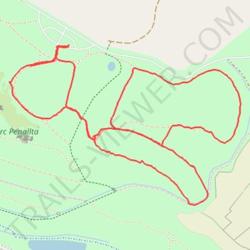
Parc Penallta
- Distance: 1.8 mi
- Elevation gain: 164 ft
- Maximum elevation: 768 ft
- Elevation loss: 180 ft
- Minimum elevation: 669 ft
- Moving time: 38 m 28 s
- Moving speed: 2.8 mph
- Maximum speed: 5.1 mph
- Total time: 41 m 9 s
- Global speed: 2.7 mph
Interactive trail map
Make a donation
Gear up for your next adventure:
As an Amazon Associate, this site earns from qualifying purchases at no extra cost to you.
Trail profile
- Distance: 1.8 mi
- Elevation gain: 164 ft
- Maximum elevation: 768 ft
- Elevation loss: 180 ft
- Minimum elevation: 669 ft
- Moving time: 38 m 28 s
- Moving speed: 2.8 mph
- Maximum speed: 5.1 mph
- Total time: 41 m 9 s
- Global speed: 2.7 mph
Make a donation
Gear up for your next adventure:
As an Amazon Associate, this site earns from qualifying purchases at no extra cost to you.
About this trail
Name: Parc Penallta trail, distance, elevation, map, profile, GPS track
Coordinates: 51.64836 -3.25627 51.65226 -3.24720
Make a donation
Gear up for your next adventure:
As an Amazon Associate, this site earns from qualifying purchases at no extra cost to you.
Other hiking, mountain biking, running and outdoor activity trails
Click on a trail to view its statistics, map and profile.
The Headstock 500
United Kingdom > Wales > Newport > Newport
Distance: 300.4 mi • Elevation gain: 31,549 ft • Maximum elevation: 2,267 ft
Treorchy, Cearphilly, Pen y Fan
United Kingdom > Wales > Caerphilly County Borough > Tredegar
Distance: 79.1 mi • Elevation gain: 6,345 ft • Maximum elevation: 1,644 ft