Thank you for supporting this site ❤️
Make a donation
Make a donation
Gear up for your next adventure:
As an Amazon Associate, this site earns from qualifying purchases at no extra cost to you.
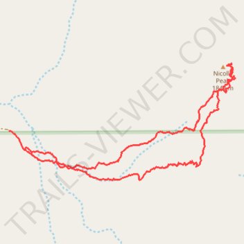
Nicolls Peak loop
- Distance: 3.0 mi
- Elevation gain: 1,909 ft
- Maximum elevation: 5,974 ft
- Elevation loss: 1,978 ft
- Minimum elevation: 3,993 ft
- Moving time: 2 h 19 m
- Moving speed: 1.3 mph
- Maximum speed: 3.0 mph
- Total time: 6 h 8 m
- Global speed: 0.5 mph
Interactive trail map
Thank you for supporting this site ❤️
Make a donation
Make a donation
Gear up for your next adventure:
As an Amazon Associate, this site earns from qualifying purchases at no extra cost to you.
Trail profile
- Distance: 3.0 mi
- Elevation gain: 1,909 ft
- Maximum elevation: 5,974 ft
- Elevation loss: 1,978 ft
- Minimum elevation: 3,993 ft
- Moving time: 2 h 19 m
- Moving speed: 1.3 mph
- Maximum speed: 3.0 mph
- Total time: 6 h 8 m
- Global speed: 0.5 mph
Thank you for supporting this site ❤️
Make a donation
Make a donation
Gear up for your next adventure:
As an Amazon Associate, this site earns from qualifying purchases at no extra cost to you.
About this trail
Name: Nicolls Peak loop trail, distance, elevation, map, profile, GPS track
Start: Kern County, California, United States (35.61496 -118.31186)
End: Kern County, California, United States (35.61605 -118.31300)
Coordinates: 35.61326 -118.31300 35.61983 -118.29727
Topography: Kern County topographic map, elevation, terrain
Thank you for supporting this site ❤️
Make a donation
Make a donation
Gear up for your next adventure:
As an Amazon Associate, this site earns from qualifying purchases at no extra cost to you.