Thank you for supporting this site ❤️
Make a donation
Make a donation
Gear up for your next adventure:
As an Amazon Associate, this site earns from qualifying purchases at no extra cost to you.
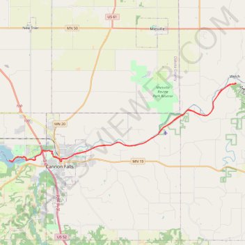
Cannon Valley Trail and Mill Towns State Trail from Welch to Echo Point on Lake Byllesby
- Distance: 27.6 mi
- Elevation gain: 1,191 ft
- Maximum elevation: 873 ft
- Elevation loss: 1,194 ft
- Minimum elevation: 712 ft
Interactive trail map
Thank you for supporting this site ❤️
Make a donation
Make a donation
Gear up for your next adventure:
As an Amazon Associate, this site earns from qualifying purchases at no extra cost to you.
Trail profile
- Distance: 27.6 mi
- Elevation gain: 1,191 ft
- Maximum elevation: 873 ft
- Elevation loss: 1,194 ft
- Minimum elevation: 712 ft
Thank you for supporting this site ❤️
Make a donation
Make a donation
Gear up for your next adventure:
As an Amazon Associate, this site earns from qualifying purchases at no extra cost to you.
About this trail
Name: Cannon Valley Trail and Mill Towns State Trail from Welch to Echo Point on Lake Byllesby trail, distance, elevation, map, profile, GPS track
Coordinates: 44.50997 -92.95447 44.56357 -92.73753
Topography: Goodhue County topographic map, elevation, terrain
Thank you for supporting this site ❤️
Make a donation
Make a donation
Gear up for your next adventure:
As an Amazon Associate, this site earns from qualifying purchases at no extra cost to you.