Make a donation
Gear up for your next adventure:
As an Amazon Associate, this site earns from qualifying purchases at no extra cost to you.
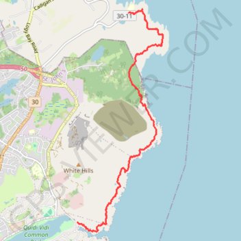
East Coast Trail - Sugarloaf Path
#Hiking #Newfoundland #Atlantic
- Distance: 5.2 mi
- Elevation gain: 1,467 ft
- Maximum elevation: 505 ft
- Elevation loss: 1,532 ft
- Minimum elevation: 7 ft
Interactive trail map
Make a donation
Gear up for your next adventure:
As an Amazon Associate, this site earns from qualifying purchases at no extra cost to you.
Trail profile
- Distance: 5.2 mi
- Elevation gain: 1,467 ft
- Maximum elevation: 505 ft
- Elevation loss: 1,532 ft
- Minimum elevation: 7 ft
Make a donation
Gear up for your next adventure:
As an Amazon Associate, this site earns from qualifying purchases at no extra cost to you.
About this trail
Name: East Coast Trail - Sugarloaf Path trail, distance, elevation, map, profile, GPS track
Coordinates: 47.58154 -52.67795 47.62452 -52.65340
Make a donation
Gear up for your next adventure:
As an Amazon Associate, this site earns from qualifying purchases at no extra cost to you.
Other hiking, mountain biking, running and outdoor activity trails
Click on a trail to view its statistics, map and profile.
St. Johns - Signal Hill - Quidi Vidi
Canada > Newfoundland and Labrador > St. John's
Signal Hill National Historic Site. #Hiking #SignalHill #Atlantic
Distance: 3.7 mi • Elevation gain: 932 ft • Maximum elevation: 489 ft